
Melanesian Island Nations Announce Collaborative Initiative for Massive Pacific Ocean Reserve Corridor
Papua New Guinea, Solomon Islands, Fiji, and Vanuatu coordinate cross-border marine protections to safeguard vulnerable fisheries and coral ecosystems.
PENN Explainer
Hear this story explained in 90 seconds.
Leaders across Melanesia have formally announced plans to establish an expansive transboundary marine reserve corridor across the Southwest Pacific Ocean. The coordinated environmental framework links coastal zones, archipelagos, and open waters belonging to Papua New Guinea, Solomon Islands, Fiji, and Vanuatu. Representatives from the partner nations unveiled the joint blueprint to build contiguous protected habitats aimed at shielding delicate coral reefs, pelagic fisheries, and marine wildlife from escalating climate impacts and unregulated exploitation.
The proposal seeks to connect established regional protected zones, such as the Manus Marine Protected Area around Mussau Island in northern Papua New Guinea, with adjacent territorial waters. Under the shared corridor plan, governments intend to harmonize fisheries management policies, coordinate maritime patrols, and establish strict baseline standards to prevent overexploitation. Fisheries authorities noted that mobile marine animals often migrate across national boundaries, making solitary territorial reserves less effective at curbing broader biodiversity declines.
International marine researchers and conservation groups have endorsed the collaborative effort as a critical milestone toward meeting global ecological targets. The Kunming-Montreal Global Biodiversity Framework adopted by United Nations member states calls for the effective protection and conservation of 30 percent of the world’s terrestrial and marine areas by the year 2030. Regional officials pointed out that creating large, interconnected corridors is indispensable for helping small island developing states achieve these benchmarks while preserving sovereign governance over their maritime exclusive economic zones.
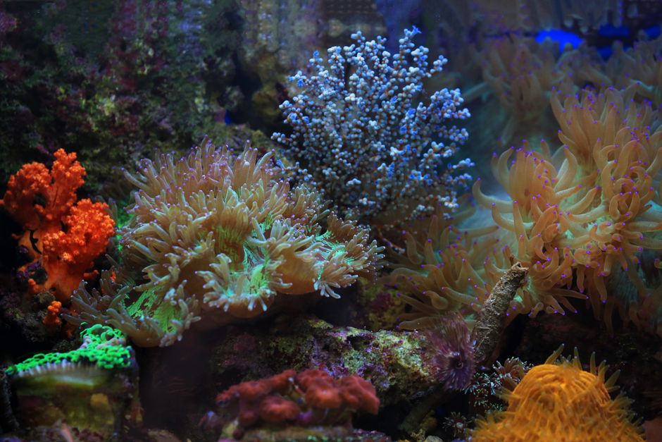
A central focus of the regional corridor initiative involves protecting coral reef systems and associated biodiversity from warming ocean temperatures and marine heatwaves. Coral reefs provide essential coastal defense against severe cyclones and ocean surges, functioning as living seawalls for low-lying island communities. Biologists surveying the Southwest Pacific note that interconnected oceanic passages allow larvae, fish populations, and marine mammals to move into more resilient thermal habitats when specific localized areas experience extreme thermal stress.
Local fishing communities form the core implementation pillar of the multilateral agreement. Melanesian customary marine tenure systems grant indigenous coastal villages traditional ownership and management authority over nearshore waters and reefs. Representatives involved in the corridor negotiations stressed that community-based marine protected areas will be formally integrated into national policies, ensuring that local fishermen retain sustainable harvesting rights while enforcing seasonal closures and gear restrictions.
Enforcement and surveillance represent significant operational challenges for participating governments managing vast stretches of the Pacific Ocean. To monitor illegal, unreported, and unregulated commercial fishing vessels inside the corridor boundaries, the partner countries plan to expand shared satellite tracking networks and joint naval patrols. Regional coordinators noted that pooling technology, data exchanges, and maritime patrol vessels will allow smaller island administrations to maximize limited enforcement budgets across thousands of square miles of ocean.
Mining and energy activities will also face tighter restrictions under the envisioned reserve network. Portions of the Southwest Pacific hold significant mineral reserves on the seabed, which have drawn interest from deep-sea mining exploration firms. Leaders collaborating on the corridor project emphasized that creating clear conservation boundaries will clarify where industrial extractive activities are prohibited to prevent permanent damage to benthic ecosystems.
Financial backing for the project is slated to come from a combination of multilateral development funds, environmental philanthropy, and sovereign climate resilience financing. Delegates indicated that discussions are underway with international banking institutions and ocean conservation funds to secure sustainable, long-term financing mechanisms. These trust funds are designed to support local ranger programs, scientific research facilities, and community-led conservation monitoring over coming decades.
Regional climate experts emphasize that small island nations remain on the front lines of global climate change despite producing negligible historical greenhouse gas emissions. Ocean acidification, coastal erosion, and unpredictable migratory patterns have placed severe burdens on local economies heavily reliant on tuna and reef fish. Organizers argue that proactive regional cooperation offers island nations the strongest collective defense against ecological shocks beyond their domestic borders.
Government delegations are scheduled to convene working technical committees over the coming months to demarcate the precise boundaries and legal mechanisms of the shared corridor. Working groups will review maritime boundary treaties, finalize enforcement protocol agreements, and align environmental impact assessment standards. If formally adopted across all participating jurisdictions, the reserve corridor could represent one of the largest interconnected community-supported marine protection initiatives in the Southern Hemisphere.
Ask the Author
Subscribers can ask the journalist a question about this story. Subscribe to ask.
Note de neutralité
Auto-harvested from global news wires and presented neutrally by PENN.
to vote
Comments
No comments yet — be the first to share your thoughts.
Related stories in Environment

Researchers Develop New Flow Battery Technology to Boost Renewable Energy Storage
2026-09-24
New Study Finds Cougars Significantly Reduce Vehicle-Deer Collisions in the United States
2026-09-24